
| HOME CONSCIOUSNESS UFOs PHOTOGRAPHY CROP CIRCLE RESEARCH PRESENTATIONS FARM MONITOR FUTURE EARTH STORE MEDIA BIOGRAPHY 2012 DEBATE CLIMATE CHANGE QUOTATIONS LETTERS BLOG CONTACT OBSERVATORY WELLNESS |
| "The views expressed by others are not necessarily shared by Colin Andrews personally. All perspectives are respected" |
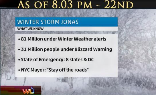
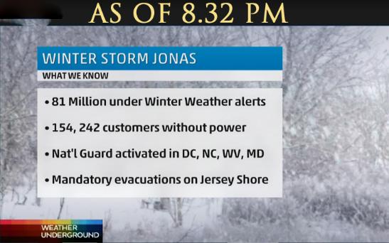
| WINTER STORM JONAS EAST COAST USA SPECIAL PAGE Posted up to date as it happens Friday 22, 2016 |
| MOST RECENT AT BOTTOM |


| REFRESH YOUR PAGE |
| Comments - 8.30 PM, 22nd: Much worse yet to come. The secondary low pressure system forecast to create the intensity of this storm system is now forming along the coast of North Carolina and tracking north. This is going to be a classic Nor Easter which is going to 'bomb out' as it moves north. |

| 9.30 pm. 22, January, 2016 Above is the wind forecast for tomorrow at 2.00 pm. Updates tomorrow 23rd. Assuming power is still on. |

| Saturday 23, 2016 |


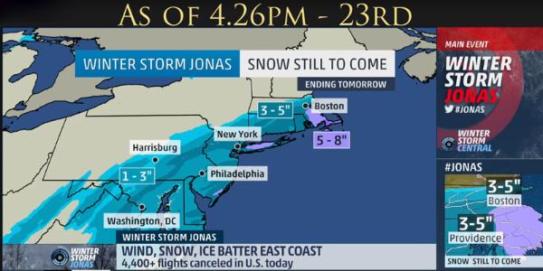
| SNOW STILL TO COME - AS AT 4.26PM, 23RD. |

| SNOW TOTALS SO FAR VARY BETWEEN 14" TO 40" |
| SERIOUS FLOODING NEW JERSEY COASTLINEg |

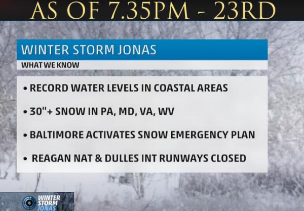
| 40" IN WEST VIRGINIA 180,000 WITHOUT POWER IN STORM AREA. |
| Posted Sat. 23 Jan, 2016. 81 MILLION UNDER WINTER WEATHER ALERTS. NATIONAL GUARD ACTIVATED IN DC, NC, WV, MD. STATES OF EMERGENCY IN 9 STATES AND DC Up to 40" of snow has fallen in places. Serious flooding on coast. 180,000 without power. Still heavy blizzard conditions. Winds 65-70 mph along coast. |
| JFK - KENNEDY AIRPORT 27.1" |
| AT 6.45 PM - 23RD 250,000 WITHOUT POWER |
| HERE ON THE FARM, IN CONNECTICUT, ITS STILL SNOWING HEAVILY WITH APPROX 18" OF SNOW. HARD TO MEASURE BECAUSE OF STRONG WINDS AND DRIFTING. PHOTOS TOMORROW. These photographs taken of the farm late today, Sat. 23rd January, 2016 |


| Below Sunday 24 January, 2016 |


| WINTER STORM JONAS January 23-24th, 2016 |