
| HA.A.R.P. in Australia |
| --------------------------------------E-mail ---------------------------------------- hi Colin, I believe the radar anomaly is due to the ionic atmospheric heater facility (haarp) at Exmouth being used to modify weather. The three cyclones present at that time all pretty much fizzled out after the discharge. You will often see this phenomenon at different locations in Oz. Many people speculate they may have something to do with mind control. Have a look at the bernd eastlund patents jointly held by Arco. I guess you have seen the cheniere.org site? Exmouth in western australia is home to the naval facility harold holt from which array this transmission emanates. You can see it very readily on google earth. They all need an oil or gas field to generate operational power. A lot of strange aerial phenomena have been seen in this area as well as some super bizarre speculations regarding the aum shintaro cult doing some weapons testing. google will tell you about it! |

| ------------------------------------------E-mail------------------------------------------ From: Subject: Re: Colin Andrews - Reply To: "Colin Andrews" <> Date: Saturday, January 23, 2010, 7:00 PM Hey Colin, I did not attach images as when you save them you only get the overlay. The background image is a static of Australia and the satellite and radar images are superimposed over the same static background image (I know I am probably telling you how to suck eggs, but jusn case). I can send images if you wish. Further you will notice an almost permanent "fan" or "circular/spiral" (whatever pattern you wish to describe) over SE Qld. If you untick the satellite box you will see what I mean, a different type of pattern exists over SW WA as well. But the other day I saw a pattern I have never seen before. I have images collected going back to 1996. BTW I used to live in SE Qld for many years, (now in Townsville) and from the ground these patterns are identifiable by clouds that are in a an almost 'wagon wheel' format all pointing to a centre! Often they are like cloud fingers, my guess is the radar at Amberly but with the location and frequency it is more likely the Golf Ball Radar (doplar) installations placed almost every 500klm around the coast to "track" (read manipulate) our weather systems. One last note currently TC Olga off North Qld seemed to (the other day) and similar now, have inner circular movement is clockwise, outer circular is counterclockwise. Paul |
| -------------------------------------Email------------------------------------- Hi Colin, Firstly, I do not want to be quoted on anything I say, my job is a bit easy to loose at the moment. Secondly, I should explain a bit more about our weather radar here, as I cannot speak for the US, as their equipment, from what I hear, is older than ours in many cases, and is more easily interfered with by outside sources, which we call AP's, or Anomalous Propagation. The email you had from the Kalgoorlie Met Office in WA mentioned this (AP), but they did not expand on their statement. By this I mean, a radio source within the bandwidth of the radar or sometimes an AP can occur when there is a weather inversion (i.e. the temperature relative to height rises instead of falls). These can cause false echoes to appear. This type of Temperature inversion scenario can occur when the radar’s signal bounces off the inversion, which creates more AP with “shape” rather than just overall speckle. I think from memory these type of radar images have only been available for the last 6 or 7 years to the general public on the Bureau of Meteorology (Australian BOM) website. The thing is, everyone thinks’ they are an expert, and the Bureau gets complaints and queries from various areas of the public, but it comes down to people having an “untrained eye” in regard to what you are “supposed to see” from this equipment. I think as time goes on, the Bureau has to be more accountable for the money spent, and people want to see more “real time” of what is happening, rather than having some “expert” interpret for them. The problem is, even the young meteorologists have to trained on how to interpret the data from these devices, since the technology is not perfect. The radars just follow the laws of physics. People can get excited over nothing at times, and essentially the Bureau is making a rod for its own back, releasing images which might contain AP’s - since they have to continually field enquiries and complaints in this regard. They then need extra qualified manpower to answer all the oddball questions. This is not to say that something like a certain frequency signal from some device, say Australian Airforce, (RAF) can't interfere with the weather radar, it can, and has been known to happen in certain areas. But, for example, in southern Western Australia there is no Airforce presence, but the image you sent from northern WA is near a couple of big RAF setups, (Broome, WA) with their own radar, and other transmitting equipment, which might interfere. The US also share a base up in that area, (much of which is underground, except the big airstrip of course, which is designed for the space shuttle to land on) so you could have something interfering. On that note, if there was something fishy going on, it would not get released on weather radar images, that is for sure. Nothing gets through like that. As I understand it, the Alaskan Tesla transmitting system which we all know as HAARP transmits at ultralow frequencies, which I will not go into in this email, but they would never show up effects of on weather radar. It is designed for sub level use, ie. underwater and through the crust of the earth. Sometimes it is used for ionisation too, (upper atmosphere) not sure how and at what frequency. Documentation on this would be hard to get, as it has certain classifications. So, if I were you, I would avoid speculating on things which show up on weather radar, as it is too easily misinterpreted. I would get in contact with someone over there in the US who works in that field, and ask them for input. Preferably someone older and trained in this field. Someone must be willing to help, and is trustworthy. Even someone retired. That's all for now, hope this helps, |
| ----------------------------------Email-------------------------------------- From: xx Subject: Re: Weather Radar To: > Date: Monday, January 25, 2010, 6:56 PM Hi Colin, Will try and dig up what I can. I am going to try and compile the images I got down the other day from the BOM I only saved the 'widget' (radar and satellite only, I have to layer it over the background image of Australia). The other issue is for example when a weather system is developing you cannot see the upper atmospheric cloud from the ground because of the low clouds and or rain. Prior to the system moving in you will see these 'finger/spoke' like wispy clouds that are almost permanent for a couple days, often if the radar is on all the time, where you can see the pattern for extended periods as opposed to intermittent bursts, the clouds will be like ripples. The difference between these and naturally occurring clouds is that they are almost geometrically shaped and aligned in grids. These grids will occur in exactly the same place in the same pattern for days. This is not natural. Will send some more info when I find it. Regards XXXX Removed |
| -----------------------------------------E-mail------------------------------------------ comments = 26th of January 2010 Hi Colin, Have just received the link to your site from someone who has as interest in what strange weather patterns we seem to have these days. The 'Australian Government' has a department called 'Ionospheric Prediction'. This 'IP' is mentioned in the publicly available data about 'JORN'. 'JORN' is mentioned on one of your pages. It is my strong belief after years of observation that there is a device located somewhere in/near the city of Melbourne which intensifies storm weather systems when necessary. I have been following the weather sytems in my part of the worldfor over 40 years. I openly say that the customary usual weather pattern changed as of 1977/1978. Feel welcoem to contact me when you have the time. Thankyou for your efforts on your site. Kindest regards, |
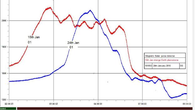
| --------------------------------------------E-mail------------------------------------------- The ULF Pulses from th Sun were different on the 15th. When I first saw the pictures of this odd phenomena it was obvious that dust could not have played any part it's construction, the radar image was too clear and consistent to be formed by chance alone. I decided to check back on my previous recordings from my detector of ULF pulses from the Sun. All those previous 12 hour recordings for January were normal, except for the one recorded on the 15th January 2010. Then I realised that the strange doughnut shape object was captured by radar, also on the 15th Jan. Hardly a coincidence. I have designed and built an Ultra Low Freqency detector, along with a unique non inductive magnetic pulse sensor element. The sensitivty of the detector is very high, and free from EM radiation interference I have also successfully recorded ULF magnetic energies, from the Sun, that have been reflected from the Moon to Earth. The "ring" is very reflective to Radar energies, possibly in the form of a well controlled plasma magnetic vortex. An important point to consider is that the image is consistent, no matter where it is discovered. Colin, I have attached a chart recording taken on the 15th of Jan 2010 and superimposed on the chart is a trace recorded on the 24th of January 2010, as a sample of a regular recording of the Sun. The reason for the narrow vertical nature of the trace is because of the Magnetic Sensor's unusually narrow beamwidth. Cheers for now Brian |
| http://www.bom.gov.au/cgi-bin/nmoc/latest_fwo_loop_R.pl?IDCODE=IDR00000&number=144 National Radar Mosaic (Hourly) |


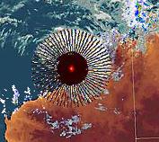
After a great deal of research for a week by myself and many others across Australia (thank you), I seem to
have identified the radar stations at the center of some of these effects. The dramatic black radial spokes
surrounding a red ruby star like feature which appeared on the national radar on January 22, 2010 at 00.00 hrs
UTC, emanated from the ground based station at Broome, WA. From the Australian Bureau of Meteorology
national radar mosaic I found the station disconnected from the national system (See Fig 3 below). At 02.00 hrs
the burst effect took place and in filled the gab in the mosaic. Whether the station was taken off line for other
operations to take place of which the radial burst was an artifact or if the effect was itself due to faulty ground
equipment is still not known but during the time the station was either deliberately turned off or failed, a notice
appeared on the system showing the radar was unavailable for reasons not made public (Fig. 07)
Fig. 01 Strange effect Jan 22.
Fig. 02 The Australian National Radar Mosaic with the Broome
ground station disconnected.
ground station disconnected.
Fig. 03 Burst coming from location of the Broome
facility.
facility.
Fig. 04 Close up of gap in radar
mosaic due to Broome taken off
stream.
mosaic due to Broome taken off
stream.
Fig. 05 Radial burst coming out of
Broome.
Broome.
Fig. 06 Ground based radar
stations including Broome.
stations including Broome.
Fig. 07 The Broome Radar system shown as currently unavailable for reasons not made public.
==========================================================================
==========================================================================

The 27th January 2010 a new and even more dramatic series of developments have
taken place - this time over Melbourne in the south east of the country.
taken place - this time over Melbourne in the south east of the country.
Fig. 01 Strange effect Jan 22.
Continue to next page >>
Back to Start of Article>>
Exmouth, HAARP Facility in Australia?
| More about HAARP |
Pentagon Scientists Target Iran’s Nuclear Mole Men
Strange New Air Force Facility Energizes Ionosphere, Fans Conspiracy Flames

| DoD News Briefing: Secretary of Defense William S. Cohen. Presenter: Secretary of |
| Easy access to whole project. |