

Fig 01 January 16: A ring shown on
radar over the South West.
radar over the South West.

Fig 02 January 22: Series of broken
concentric rings over Melbourne in the
south east.
concentric rings over Melbourne in the
south east.
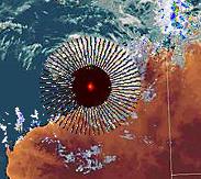
Fig 03 January 22: Black radial
spokes from a ruby red star
centre over Broome, in the
North West.
spokes from a ruby red star
centre over Broome, in the
North West.

Fig 04 January 27: Black
spiraling radial arms from a
much larger ruby red star center,
this time over the south east..
The same facility as the event of
the 22nd seen in Fig 02.
spiraling radial arms from a
much larger ruby red star center,
this time over the south east..
The same facility as the event of
the 22nd seen in Fig 02.

| Just a reminder Norway Spiral. Select the photo |


Saturday January 30, 2010.
Tropical Cyclone Olga and an active monsoonal trough are bringing heavy
rain and strong winds to the tropics, particularly QLD. A weak trough
extending over southern QLD is causing the odd storm. Skies are remaining
mostly clear in the south under a high pressure ridge.
Issued Saturday 05:49 EDT
http://www.weatherzone.com.au/synoptic.jsp?d=0&c=satsyn
Jan 30 - This is the new low pressure system which formed
under the Jan 27 Melboure HAARP ? burst. Was it engineered
to reinforce what is now major cyclone Olga, positioned over
the north of the country - watch this low pressure system.
under the Jan 27 Melboure HAARP ? burst. Was it engineered
to reinforce what is now major cyclone Olga, positioned over
the north of the country - watch this low pressure system.
Tropical Cyclone Olga now formed over the north of Australia. Watch the HAARP "
produced Low pressure system now rising north from its construction zone over Melbourne
on the 27th.
produced Low pressure system now rising north from its construction zone over Melbourne
on the 27th.
Tropical Cyclone and sudden increase in more severe weather over Australia. Are all the
various new radar phenomenon I have been monitoring since January 16th been weather
modification engineering via HAARP with other ground based installations?
various new radar phenomenon I have been monitoring since January 16th been weather
modification engineering via HAARP with other ground based installations?
Another quick recap
These are two screen grabs which its claimed to have been taken off of the radar
coming from the Broome facility on January 28th, 2010. The geometry consists of an
amalgam of both the radial and spiral arms. The very first black radiating lines was seen
here at this site on January 27th.
I have yet to obtain confirmation of this event in the Bureau Archives but in light of the
events developing surrounding Cyclone Ogla I judged I should post it now anyway.
January 28: This new
design from the Broome
radar station in the north
west which was one of two
events there today (seen
above)
design from the Broome
radar station in the north
west which was one of two
events there today (seen
above)
As Ive continued to monitor the weather and national radar system over
Australia with the help of many people in that country since January 16th.
Various strange symbols have appeared, some experts within the Bureau
said these have not been seen before. A new weather system formed
under the event of the 27th over Melbourne which perhaps coincidentally
resembled the spiral seen in the sky over Norway last year. That low
pressure system is now moving north and is likely to be sucked into a
major tropical cyclone Olga positioned over the north of the country.
During this short period the general weather situation has moved from
quiet to very active and in parts serious. Is all this coincidence>
Have we seen the first weather modification engineered in front of our very
eyes? For now lets look at the facts and .....Watch what happens to that
new Low pressure system. Will the cyclone deepen or break up as the
new system approaches - we will be monitoring.
Posted January 29, 2010
Colin Andrews

Two New Bursts over the North West of Australia as the HAARP
Melbourne Low Pressure System heads towards Cyclone Olga - Watch
this low.
Waiting to hear from top expert in Australia.
Colin Andrews
Posted January 29, 2010.
Melbourne Low Pressure System heads towards Cyclone Olga - Watch
this low.
Waiting to hear from top expert in Australia.
Colin Andrews
Posted January 29, 2010.
Back to the original article
| -------------------------E-mail-------------------------- Forwarded to Colin Andrews: Radar returns (signals) are composed of microwaves. That goes for weather satellite radars. The Cabal have orbiting Star Wars weapons satellites some of which have on-board computer-controlled directed-energy microwave beam weapons. Thus the Cabal can make hash of weather radar returns (signal patterns), or create substitute radar returns anytime they wish. Being egotistical, the Cabal like to show off their shiny new toys. in the light, Richard Boylan, Ph.D. |
Former United States Governor of Minnesota Jesse Ventura investigates HAARP
Posted 2200 hrs January 31, 2010
USA eastern.
Colin Andrews
Well we have our answer. We have been monitoring a new Low Pressure
System which mysteriously formed over Melbourne last week. The Low
pressure system which was manufactured or formed dependant upon your
view, when a bizarre spiral appeared on radar over Melbourne on January 27th
2010. The 'Melbourne Low' formed directly over the city and moved up the
east coast when it kicked to the north east honing in on a newly formed
dangerous cyclone 'Olga'. Again dependant upon your view if these events are
natural or are the results of weather modification or even warfare, the low
destroyed Olga or it dissipated.
After this website brought attention to these events and the monitoring of
events was made public as we watched closely the new Low and the Melbourne
Radar, that radar station was taken off line and not made available to the public
- it is still off as I post this update (01.30 UTC Feb 1 : 2200 hrs USA Eastern Jan
31.) What is curious is that the public notice states it was taken out of service
on the 18th of January which preceded all the activity we have been reporting
on, this is patently untrue. The most unusual radar geometry seen came from
this radar station on the 27th. Its as if the Bureau is back tracking and trying to
remove themselves from the data and events. The caption below as seen
throughout Australia on the Bureau Weather Radar network. See also the
weather chart and visible satellite image showing Olga now gone and a new
tropical low forming over the south east. This time however the Melbourne
Radar facility is no longer available to the public to monitor. The link to the
national network is :


Tropical cyclone Olga now destroyed over the northern parts as a new tropical low forms over the eastern
sea boards but this time the Melbourne radar facility has been taken off stream and the public can not
monitor events from that region as we did last week. The Bureau Site is HERE
sea boards but this time the Melbourne radar facility has been taken off stream and the public can not
monitor events from that region as we did last week. The Bureau Site is HERE
Since my website began monitoring events over Melbourne closely and the public
became engaged in strange weather changes occurring in front of our eyes, the
primary station of interest was taken off stream. What appeared to be an artificially
produced Low pressure system (I called the Melbourne Low) moved up the coast and
towards the cyclone Olga - dangerous storm Olga collapsed suddenly as if bursting a
bubble as the Melbourne Low merged with it.
| Updated January 31, 2010 |
| Updates below |
On January 29, NASA made comment about the unusual persistence
of the then tropical storm Olga:
NASA
Just like 1980s song by the Commodores, "Three Times a Lady," Olga has become a
tropical storm for the third time in northern Australia. NASA satellite imagery showed
that Olga's center moved back into the warm waters of the Gulf of Carpentaria and it
has regained strength.
NASA's Aqua satellite saw Olga's center re-entering the Gulf early on January 29, and
satellite imagery indicated the storm was strengthening.
Residents of the northern coastal areas in Australia's Northern Territory and
Queensland are again under tropical cyclone warnings and watches, now that Olga is
back in the Gulf. Olga isn't expected to stay in the Gulf more than a day, however,
before it makes landfall near Normanton, Queensland on January 30.
A Cyclone Warning remains in effect for coastal and island communities from the
Northern Territory/Queensland border to Kowanyama extending inland to Croydon in
Queensland..... Full report:
http://www.nasa.gov/mission_pages/hurricanes/archives/2010/h2010_Olga.html
Newspaper report about Olga HERE

| Updated February 1, 2010 |
An unplanned case study into strange weather over Australia. Out of a
single radar ring report came a persistent cyclone Olga and a weather
busting seventeen days. I just happened to monitor it all unfold. Was it
the perfect cup of tea by HAARP?
Final Comments:
By Colin Andrews
Posted February 1, 2010
From an almost casual report of a strange but by no means unseen before radar design
over the south west of Australia on January 16th 2010 came a whole series. These grew
over the days in complexity and rareness, several apparently never seen before. During the
17 days of study a very persistent tropical storm Olga appeared on the scene. A new Low
pressure system formed directly under the strangest of all radar patterns over the south
east which headed towards Olga. Then it was just like watching an Englishman working with
a tea bag to obtain a perfect cup of tea for his taste. Tropical storm Olga seemed
manipulated and maneuvered into a Cyclone which then became too strong for his taste and
so a new Low was added to the cup to adjust that strength. After all was said and done, the
taste was perfected and in so doing instead of wide spread damage caused to large parts of
Australia, a good soaking was given to seriously parched areas suffering water shortages in
that country. Like the unbelievable 'antics' of Hurricane Katrina in 2005 which went into a
hold pattern over the Carolina coast as its strength and course seemed to be fine tuned
these huge and powerful systems looked like they were different to all the rest. Like they had
a hand on them.
Whether this study along with others can support a case for weather engineering at work I
don’t know but many aspects of this period have been fascinating and rest here to be tested
again in the future. HAARP exists and its implications are unknown but to many its existence
with no form of controls by our representatives is very concerning. God or a higher
intelligence will by some also be a contender for these events but for now we know that we
are a planet and species in rapid transition and so new signs of change can be expected. It
would probably be more assuring if we knew they came from nature herself.
Colin Andrews
Feb 1, 2010. February 4, 2010 - IT DIDNT END HERE - BOTTOM PAGE
| Updated February 1, 2010 |

A new ring captured to the north of the old Cyclone Olga, appearing to nudge it
south towards the very place spot the new Melbourne Low formed January 27,
just six days ago BEFORE the big weather buster cyclone Olga formed.
Thank you to those observers in Australia who are continuing to watch the
weather changes taking shape.
south towards the very place spot the new Melbourne Low formed January 27,
just six days ago BEFORE the big weather buster cyclone Olga formed.
Thank you to those observers in Australia who are continuing to watch the
weather changes taking shape.
| -------------------------------------E-mail ---------------------------------- name = Sarah email = XXX Given but removed comments = Hi Colin, Your website is always such a fascinating pleasure. Thank you for the interesting read. I found this post from early January rather coincidental: On January 4th, Benjamin Fulford said 'One group centered on the British empire would like to begin construction of massive free energy facilities to remove salt from sea-water and use the resulting fresh water to turn the deserts green. This group is allying itself with the Middle Eastern monarchies and plans to work simultaneously in Australia and the Arabian peninsula. This group also wants to pay the world’s deep sea fishing fleets to stop all fishing for two or three years in order to allow the oceans to replenish themselves. A different group based in Australia but with powerful connections throughout the G7 proposes turning the deserts green by using etheric weather engineering technology' You can find his January 4th post nested within David Wilcock's blog: http://divinecosmos.com/index.php? option=com_content&task=blogcategory&id=29&Itemid=70 |
| Updated February 2, 2010 |
| 63 |
Next page: "Houston we have a problem" - Radar system goes into meltdown
NOTICE UNCLE SAM? DOES NOT SEEM TO LIKE THIS ON MY WEBSITE. IT HAS BEEN DELETED SEVERAL TIMES. AS OF NOW (2010-0303 IVE REINSTALLED IT). |
| If you find it deleted please inform me HERE |
| Easy access to each stage of this project. |